


At dawn (September 16), I began the short march leading to the Yellala.[FN#29] By stepping a few paces south of Nkulu, we had a fine view of the Borongwa ya Vivi, the lowest rapids, whose foaming slope contrasted well with the broad, smooth basin beyond. Palabala, the village of Nekorado on the other side of the stream, bore south (Mag.), still serving as a landmark; and in this direction the ridges were crowned with palm orchards and settlements. But the great Yellala was hidden by the hill- shoulder.
We at once fell into a descent of some 890 feet, which occupied an hour. The ground was red iron-clay, greasy and slippery; dew- dripping grass, twelve to fifteen feet tall, lined the path; the surface was studded with dark ant-hills of the mushroom shape; short sycomores appeared, and presently we came to rough gradients of stone, which severely tried the "jarrets." After an hour, we crossed at the trough-foot a brook of pure water, which, uniting with two others, turns to the north-east, and, tumbling over a little ledge, discharges itself into the main drain. An ascent then led over a rounded hill with level summit, and precipitous face all steps and drops of rock, some of them six and seven feet high, opposed to the stream. Another half hour, and a descent of 127 feet placed us under a stunted calabash, 100 feet above the water, and commanding a full view of the Yellala.
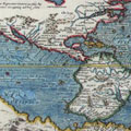
On the whole, the impression was favourable. Old Shimbah, the Linguister at Porto da Lenha, and other natives had assured me that the Cataracts were taller than the tallest trees. On the other hand, the plain and unadorned narrative of the "Expedition" had prepared me for a second-rate stream bubbling over a strong bed. The river here sweeps round from the north-west, and bends with a sharp elbow first to the south-west and then to the south- east, the length of the latter reach being between four and five miles. As far as the eye can see, the bed, which narrows from 900 to 400 and 500 yards, is broken by rocks and reefs. A gate at the upper end pours over its lintel a clear but dwarf fall, perhaps two feet high. The eastern staple rises at first sheer from the water's edge to the estimated altitude of a thousand feet, - this is the "Crocodile's Head" which we saw on the last march, and already the thin rains are robing its rocky surface with tender green. The strata are disposed at angles, varying from 35deg. to 45deg., and three streaks of bright trees denote Fiumaras about to be filled. Opposite it is the "Quoin Hill," bluff to the stream, and falling west with gradual incline. The noise of this higher fall can hardly be heard at Nkulu, except on the stillest nights.
Below the upper gate, the bed, now narrowing to 300 yards, shows the great Yellala; the waters, after breaking into waves for a mile and a half above, rush down an inclined plane of some thirty feet in 300 yards, spuming, colliding and throwing up foam, which looks dingy white against the dull yellow-brown of the less disturbed channel - the movement is that of waves dashing upon a pier. The bed is broken by the Zunga chya Malemba, which some pronounced Sanga chya Malemba, an oval islet in mid-stream, whose greater diameter is disposed along the axis of the bed. The north-western apex, raised about fifty feet above the present level of the waters, shows a little bay of pure sand, the detritus of its rocks, with a flood-mark fifteen feet high, whilst the opposite side bears a few wind-wrung trees. The materials are gneiss and schist, banded with quartz - Tuckey's great masses of slate. This is the "Terrapin" of the Nzadi. The eastern fork, about 150 yards broad, is a mountain-torrent, coursing unobstructed down its sandy trough, and, viewed from an eminence, the waters of the mid-channel appear convex, a shallow section of a cylinder, - it is a familiar shape well marked upon the St. Lawrence Rapids. The western half is traversed by a reef, connecting the islets with the right bank. During August, this branch was found almost dry; in mid-September, it was nearly full, and here the water breaks with the greatest violence. The right bank is subtended for some hundred yards by blocks of granite and greenstone, pitted with large basins and pot-holes, delicately rounded, turned as with a lathe by the turbid waters. The people declare that this greenstone contains copper, and Professor Smith found particles in his specimens. The Portuguese agents, to whom the natives carefully submit everything curious, doubt the fact, as well as all reports of gold; yet there is no reason why the latter should not be found.
The current whirls and winds through its tortuous channels, which are like castings of metal, in many distinct flows; some places are almost stagnant, suggesting passages for canoes. Here the fishermen have planted their weirs; some are wading in the pools, others are drying their nets upon the stony ledges. During the floods, however, this cheval-de-frise of boulders must all be under water, and probably impassable. Tuckey supposes that the inundation must produce a spectacle which justifies the high- flown description of the people. I should imagine the reverse to be the case; and Dr. Livingstone justly remarked[FN#30that, when the river was full, the Yellala rapids would become comparatively smooth, as he had found those of the Zambeze; and that therefore a voyage pittoresque up the Congo should be made at that season.
Before leaving the Yellala, I wandered along the right bank, and found a cliff, whose overhanging brow formed a fine cavern; it remarkably resembled the Martianez Fountain under the rock near the beautiful Puerto de Orotava. Here the fishermen were disporting themselves, and cooking their game, which they willingly exchanged for beads. All were of the Silurus family, varying from a few inches to two feet. Fish-eagles sat upon the ledges overhanging the stream, and a flight of large cranes wheeled majestically in the upper air: according to the people, they are always to be seen at the Yellalas.
The extent of a few hundred feet afforded a good bird's eye view of the scene. The old river-valley, shown by the scarp of the rocks, must have presented gigantic features, and the height of the trough-walls, at least a thousand feet, gives the Yellala a certain beauty and grandeur. The site is apparently the highest axis of the dividing ridge separating the maritime lowlands from the inner plateau. Looking eastward the land smoothens, the dorsa fall more gently towards the counter-slope, and there are none of the "Morros" which we have traversed.
With the members of the Congo Expedition, I was somewhat startled by the contrast between the apparently shrunken volume of waters and the vast breadth of the lower river; hence Professor Smith's theory of underground caverns and communications, in fact of a subterraneous river, a favourite hobby in those days. But there is not a trace of limestone formation around, nor is there the hollow echo which inevitably would result from such a tunnel. Evidently the difference is to be accounted for by the rapidity of the torrent, the effect of abnormal slope deceiving the eye. At the Mosi-wa-tunya Falls the gigantic Zambeze, from a breadth of a thousand yards suddenly plunges into a trough only forty- five to sixty feet wide: the same is the case with the Brazilian Sao Francisco, which, a mile wide above the Cachoeira de Paulo Affonso, is choked to a minimum breadth of fifty-one feet. At the Pongo (narrows) de Manseriche also, the Amazonas, "already a noble river, is contracted at its narrowest part to a width of only twenty-five toises, bounded on each margin by lofty perpendicular cliffs, at the end of which the Andes are fairly passed, and the river emerges on the great plain."[FN#31] Thus the Yellala belongs to the class of obstructed rapids like those of the Nile, compared with the unobstructed, of which a fine specimen is the St. Lawrence. It reminded me strongly of the Busa (Boussa) described by Richard Lander, where the breadth of the Niger is reduced to a stone-throw, and the stream is broken by black rugged rocks arising from mid-channel. It is probably a less marked feature than the Congo, for in June, after the "Malka" or fourteen days of incessant rain, the author speaks of whirlpools, not of a regular break.
I thus make the distance of the Yellala from the mouth between 116 and 117 miles and the total fall 390 feet, of which about one half (195) occurs in the sixty-four miles between Boma and the Yellala: of this figure again 100 feet belong to the section of five miles between the Vivi and the Great Rapids. The Zambeze, according to Dr. Livingstone ("First Expedition," p. 284), has a steeper declivity than some other great rivers, reaching even 7 inches per mile. With 3 to 4 inches, the Ganges, the Amazonas, and the Mississippi flow at the rate of three knots an hour in the lowest season and five or six during the flood: what, then, may be expected from the Nzadi?
According to the people, beyond the small upper fall where projections shut out the view, the channel smoothens for a short space and carries canoes. Native travellers from Nkulu usually take the mountain-path cutting across an easterly bend of the bed to Banza Menzi, the Manzy of Tuckey's text and the Menzi Macooloo of his map. It is situated on a level platform 9 miles north of Nkulu, and they find the stream still violent. The second march is to Banza Ninga, by the First Expedition called "Inga," an indirect line of five hours = 15 miles. The third, of about the same distance, makes Banza Mavunda where, 20 to 24 miles above the Yellala, Tuckey found the river once more navigable, clear in the middle and flowing at the rate of two miles an hour - a retardation evidently caused by the rapids beyond: I have remarked this effect in the Brazilian "Cachoeiras."[FN#32] Above it the Nzadi widens, and canoeing is practicable with portages at the two Sangallas. The southern feature, double like the Yellala, shows an upper and a lower break, separated by two miles, the rapids being formed as usual by sunken ledges of rock. Two days' paddling lead to the northern or highest Sangalla, which obstructs the stream for 22 miles: Tuckey (p. 184) makes his Songo Sangalla contain three rapids; Prof. Smith, whose topography is painfully vague, doubles the number, at the same time he makes Sanga Jalala (p. 327) the "uppermost fall but one and the highest." Finally, at Nsundi (on the map Soondy N'sanga), which was reached on Sept. 9, a picturesque sandy cove at the opening of a creek behind along projecting point, begins a lake- like river, three miles broad, with fine open country on both banks: the explorer describes it as "beautiful scenery equal to anything on the banks of the Thames."
Here the Nzadi is bounded by low limestone hills already showing the alluvial basin of Central Africa; and the land is well populated, because calcareous districts are fertile in the tropics and provisions are plentiful. Prof. Smith (p. 336) was "so much enraptured with the improved appearance of the country and the magnificence of the river, that it was with the greatest difficulty he was prevailed on to return." Of course, the coaster middle-men report the people to be cannibals.
From the Vivi Rapids to Nsundi along the windings of the bed is a total of 115 miles, about the distance of Vivi to the sea; the direct land march was 75 miles. Captain Tuckey heard nothing of the Lumini River entering 43 leagues above the Yellala, and he gives no professional opinion touching the navigability of the total of six greater rapids which, to judge from what I saw, can hardly offer any serious obstruction to the development of the Nzadi.
At Nkulu an intelligent native traveller whom I examined through the interpreters, strongly advised the line of the southern bank: five stages would lead to Nsundi, and the ten "kings" on the road are not such "rapacious gentlemen" as our present hosts. A glance at Tuckey's map shows that this southern line cuts across a long westerly deflection of the bed.
I had been warned when setting out that a shipful of goods would not take me past Nkulu. This was soon confirmed. On the evening after arrival I had directed my interpreter to sound the "bush- kings" touching the expense of a march to Nsundi. They modestly demanded 100 lbs. of beads, fifty kegs of powder, forty demijohns of rum, twelve uniforms, ten burnuses, a few swords, and 200 whole pieces of various expensive cloths, such as Costa Finas, Riscados, and satin stripes, - briefly, about L300 for three days' march. It suggested the modest demand made by King Adooley of Badagry, from the brothers Lander.
The air of Nkulu was a cordial; the aspect of the land suggested that it is the threshold to a country singularly fertile and delicious, in fact, the paradise which Bishop Berkeley (Gaudentio di Lucca) placed in Central Africa. The heat of the lowlands had disappeared, -
"The scorching ray
Here pierceth not, impregnate with disease."
The thermometer, it is true, did not sink below 67deg. (F.), whilst the "Expedition" (p. 118) had found it 60deg. in August, even at Boma during the dewy nights. The lowest temperature of the water was 75deg., and the highest 79deg., whereas at the mouth it is sometimes 83deg.; Tuckey gives 76deg.-77deg.; 74deg. in the upper river above the Falls, and 73deg. where there are limestone springs. The oxydization of iron suddenly ceased; after a single day's drying, the plants were ready for a journey to England, and meat which wrill hardly keep one day in the lowlands is here eatable on the fifth.
Whilst the important subject of "dash" was being discussed I set out in my hammock to visit a quitanda or market held hard by. As we started, the women sang,
"Lungwa u telemene ko
Mwanza Ko Yellala o kwenda."
"The boat that arrives at the Mwanza (the River) the same shall go up to the Yellala" (rapids). It is part of a chant which the mothers of men now old taught them in childhood, and the sole reminiscence of the Congo Expedition, whose double boats, the Ajojos of the Brazil, struck their rude minds half a century ago.
These quitandas are attended by people living a dozen miles off, and they give names to the days, which consequently everywhere vary. Thus at Boma Friday, Saturday, Sunday, and Monday are respectively called "Nkenge," "Sona," "Kandu," and "Konzo." This style of dividing time, which is common throughout Pagan West Africa, is commonly styled a week: thus the Abbe Proyart tells us that the Loango week consists of four days, and that on the fourth the men "rest" by hunting and going to market. Tuckey also recognizes the "week of four days," opposed to the seven days' week of the Gold Coast.
After half an hour's run to the north-west my bearers, raising loud shouts of "Alii! vai sempre!" dashed into the market-place where about a hundred souls were assembled. The women rose in terror from their baskets and piles of vendibles; some began hastily to pack up, others threw themselves into the bush. Order was soon restored by the interpreter; both sexes and all ages crowded round me with hootings of wonder, and, when they had stared their fill, allowed me to sit down under a kind of ficus, not unlike the banyan-tree (Ficus Indica). Tuckey (p. 181) says that this fig is planted in all market-places and is considered sacred; his people got into trouble by piling their muskets against one of them: I heard of nothing of the kind. The scanty supplies - a few fowls, sun-dried fish, kola-nuts, beans, and red peppers - were spread upon skins, or stored in well-worked baskets, an art carried to perfection in Africa; even the Somali Bedawin weave pots that will hold water. The small change was represented by a medium which even Montesquieu would not set down as a certain mark of civilization. The horse-shoe of Loggun (Denham and Clapperton), the Fan fleam, the "small piece of iron like an ace of spades on the upper Nile" (Baker), and the iron money of the brachycephalic Nyam-nyams described and drawn by Schwein furth (i. 279), here becomes a triangle or demi-square of bast-cloth, about 5 inches of max. length, fringed, coloured like a torchon after a month of kitchen use, and worth one-twentieth of the dollar or fathom of cloth. These money-mats or coin-clouts are known to old travellers as Macuitas and Libonges (in Angolan Libangos). Carli and Merolla make them equivalent to brass money; the former were grass-cloth a yard long, and ten = 100 reis; in 1694 they were changed at Angola for a small copper coin worth 2 1/2 d., and the change caused a disturbance for which five soldiers were shot. Silver was represented by "Intagas," thick cottons the size of two large kerchiefs (=. Is. 6d.) and "Folingas," finer sorts used for waist-cloths (=. 3s. 6d.); and gold by Beirames (alii Biramis): Carli says the latter are coarse Indian cottons 5 ells long and each = 200 reis; others describe them as fine linen each piece worth 7s. 6d. to 8s. The bank-note was the "Indian piece or Mulech, a young black about twenty years of age, worth 20 Mil Keys (dollars) each." (Carli.) In the Barbots' day each "coin-clout") was equivalent to 2d.; some were unmarked, whilst others bore the Portuguese arms single or double. The wilder Kru-men still keep up their "buyapart" (= 25 cents), a cloth 4 inches square and thickly sewn over with cowries.
The only liquor was palm wine in huge calabashes. The smoking of Lyamba (Bhang or Cannabis sativa) seems to become more common as we advance. I did not find the plant growing, as did Dr. Livingstone at Linyanti and amongst the Batoka ("First Expedition," 198, 541). The pipe is the gourd of a baobab, which here sometimes grows a foot and a half long; it is cleared, filled with water and provided with a wooden tube fixed in the upper part away from the mouth, and supporting a small "chillam" or bowl of badly baked clay. The people when smoking affect the bunched shoulders, the deep inhalation, and the loud and body- shaking bark, which seems inseparable from the enjoyment of this stimulant. I have used it for months together, and my conclusion is, that mostly the cough is an affectation. Tobacco is smoked in the usual heavy clay pipes, with long mouthpieces of soft wood, quite as civilized as the best European. "Progress" seems unknown to the pipe; the most advanced nations are somewhat behind the barbarians, and in the matter of snuff the Tupi or Brazilian savage has never been rivalled.
The greater part of the vendors seemed to be women, of the buyers men; there was more difference of appearance than in any European fair, and the population about Nkulu seemed to be a very mixed race. Some were ultra-negro, of the dead dull-black type, prognathous and long-headed like apes; others were of the red variety, with hair and eyes of a brownish tinge, and a few had features which if whitewashed could hardly be distinguished from Europeans. The tattoo was remarkable as amongst the tribes of the lower Zambeze.[FN#33] There were waistcoats, epaulettes, braces and cross-belts of huge welts, and raised polished lumps which must have cost not a little suffering; the skin is pinched up between the fingers and sawn across with a bluntish knife, the deeper the better; various plants are used as styptics, and the proper size of the cicatrice is maintained by constant pressure, which makes the flesh protrude from the wound. The teeth were as barbarously mutilated as the skin; these had all the incisors sharp-tipped; those chipped a chevron-shaped hole in the two upper or lower frontals, and not a few seemed to attempt converting the whole denture into molars. The legs were undeniably fine; even Hieland Mary's would hardly be admired here. Whilst the brown mothers smoked and carried their babies, the men bore guns adorned with brass tacks, or leaned upon their short, straight, conical "spuds" and hoes, long-handled bits of iron whose points, after African fashion, passed through the wood. I nowhere saw the handsome carved spoons, the hafts and knife-sheaths figured by the Congo Expedition.
We left the quitanda with the same shouting and rushing which accompanied my appearance.