

Cassini—Picard and La Hire—The arc of the Meridian and the Map of France—G. Delisle and D'Anville—The Shape of the Earth—Maupertuis in Lapland—Condamine at the Equator.
Before we enter upon a recital of the great expeditions of the eighteenth century, we shall do well to chronicle the immense progress made during that period by the sciences. They rectified a crowd of prejudices and established a solid basis for the labours of astronomers and geographers. If we refer them solely to the matter before us, they radically modified cartography, and ensured for navigation a security hitherto unknown.
Although Galileo had observed the eclipses of Jupiter's satellites as early as 1610, his important discovery had been rendered useless by the indifference of Governments, the inadequacy of instruments, and the mistakes committed by his followers.
In 1660 Jean Dominique Cassini published his "Tables of the Satellites of Jupiter," which induced Colbert to send for him the following year, and which obtained for him the superintendence of the Paris Observatory.
In the month of July, 1671, Philippe de la Hire went to Uraniborg in the Island of Huen, to take observations for the situation of Tycho Brahe's Observatory. In that spot he calculated with the assistance of Cassini's Tables, and with an exactitude never before obtained, the difference between the longitudes of Paris and Uraniborg.
The Academy of Sciences sent the astronomer Jean Richter the same year to Cayenne, to study the parallaxes of the sun and moon, and to determine the distance of Mars and Venus from the earth. This voyage, which was entirely successful, was attended with unforeseen consequences, and resulted in inquiries shortly after entered into as to the shape of the earth.
Richter noticed that the pendulum lost two minutes, twenty-eight seconds at Cayenne, which proved that the momentum was less at this place than at Paris. From this fact, Newton and Huyghens deduced the flatness of the Globe at the Poles. Shortly afterwards, however, the computation of a terrestrial degree given by Abbé Picard, and the determination of the Meridional arc, arrived at by the Cassinis, father and son, led scientific men to an entirety different result, and induced them to consider the earth an elliptical figure, elongated towards the polar regions. Passionate discussions arose from this decision, and in them originated immense undertakings, from which astronomical and mathematical geography profited.
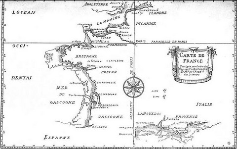
Picard undertook to estimate the space contained between the parallels of Amiens and Malvoisine, which comprises a degree and a third. The Academy, however, decided that a more exact result could be obtained by the calculation of a greater distance, and determined to portion out the entire length of France, from north to south, in degrees. For this purpose, they selected the meridian line which passes the Paris Observatory. This gigantic trigonometrical undertaking was commenced twenty years before the end of the seventeenth century, was interrupted, and recommenced, and finally finished towards 1720.
At the same time Louis XIV., urged by Colbert, gave orders for the preparation of a map of France. Men of science undertook voyages from 1679 to 1682, and by astronomical observations found the position of the coasts on the Ocean and Mediterranean. But even these undertakings, Picard's computation of the Meridional arc, the calculations which determined the latitude and longitude of certain large cities in France, and a map which gave the environs of Paris in detail with geometrical exactitude, were still insufficient data for a map of France.
As in the measurement of the Meridional arc, the only course to adopt was to cover the whole extent of the country with a network of triangles. Such was the basis of the large map of France which justly bears the name of Cassini.
The result of the earlier observations of Cassini and La Hire was to restrict France within much narrower limits than had hitherto been assigned to her.
Desborough Cooley in his "History of Voyages," says, "They deprived her (France) of several degrees of longitude in the length of her western coast, from Brittany to the Bay of Biscay. And in the same way retrenched about half a degree from Languedoc and La Provence." These alterations gave rise to a "bon-mot." Louis the XIV., in complimenting the Academicians upon their return, remarked, "I am sorry to see, gentlemen, that your journey has cost me a good part of my kingdom!"
So far, however, cartographers had ignored the corrections made by astronomers. In the middle of the seventeenth century, Peiresc and Gassendi had corrected upon the maps of the Mediterranean a difference of "five hundred" miles of distance between Marseilles and Alexandria. This important rectification was set aside as non-existent until the hydrographer, Jean Matthieu de Chazelles, who had assisted Cassini in his labours, was sent to the Levant to draw up a coast-chart for the Mediterranean.
"It was sufficiently clear," say the Memoirs of the Academy of Sciences, that the maps unduly extended the Continents of Europe, Africa, and America, and narrowed the Pacific Ocean between Asia and Europe. These errors had caused singular mistakes. During M. de Chaumont's voyage, when he went as Louis XIV.'s ambassador to Siam, the pilots, trusting to their charts, were mistaken in their calculations, and both in going and in returning went a good deal further than they imagined. In proceeding from the Cape of Good Hope to the island of Java they imagined themselves a long way from the Strait of Sunda, when in reality they were more than sixty leagues beyond it. And they were forced to put back for two days with a favourable wind to enter it. In the same way upon their return voyage from the Cape of Good Hope to France, they found themselves at the island of Flores, the most western of the Azores, when they conceived themselves to be at least a hundred and fifty leagues eastward of it. They were obliged to navigate for twelve days in an easterly direction in order to reach the French coast. As we have already said, the corrections made in the map of France were considerable. It was recognized that Perpignan and Collioures more especially were far more to the east than had been supposed. To gain a fair idea of the alteration, one has only to glance at the map of France published in the first part of the seventh volume of the memoirs of the Academy of Sciences. All the astronomical observations to which we have called attention are noted in it, and the original outline of the map, published by Sanson in 1679, makes the modification apparent.
|
|
| Map of France, corrected by order of the king, in accordance with the instructions of the Members of the Academy of Sciences. (Fac-simile of early engraving.) |
Cassini was right in saying that cartography was no longer at its height as a science. In reality, Sanson had blindly followed the longitudes of Ptolemy, without taking any note of astronomical observations. His sons and grandsons had simply re-edited his maps as they were completed, and other geographers followed the same course.
William Delisle was the first to construct new maps, and to make use of modern discoveries. He arbitrarily rejected all that had been done before his time. His enthusiasm was so great that he had entirely carried out his project at the age of twenty-five. His brother, Joseph Nicolas, who taught astronomy in Russia, sent William materials for his maps. At the same time his younger brother, Delisle de la Ceyére, visited the coast of the Arctic Ocean, and astronomically fixed the position of the most important points. He embarked on board De Behring's vessel and died at Kamtchatka. That was the work of the three Delisles, but to William belongs the glory of having revolutionized geography.
"He succeeded," says Cooley, "in reconciling ancient and modern computations, and in collecting an immense mass of documents. Instead of limiting his corrections to any one quarter of the earth, he directed them to the entire globe. By this means he earned the right to be considered the founder of modern geography."
Peter the Great, on his way to Paris, paid a tribute to his merit by visiting him, and placing at his disposal all the information he himself possessed of the geography of Russia.
Could there be a more conclusive testimony to his worth than this from a stranger? and if French geographers are excelled in these days by those of Germany and England, is it not consolatory and encouraging to them to know, that they have excelled in a science, in which they are now struggling to regain their former superiority?
Delisle lived to witness the success of his pupil, J. B. d'Anville. If the latter is inferior to Adrian Valois in the matter of historical science, he deserved his high fame for the relative improvement of his outlines, and for the clear and artistic appearance of his maps.
"It is difficult," says M. E. Desjardins, in his "Geographie de la Gaule Romaine," "to understand the slight importance which has been attributed to his works as a geographer, mathematician, and draughtsman." The latter more especially do justice to his great merit. D'Anville was the first to construct a map by scientific methods, and that of itself is sufficient glory. In the department of historical geography, D'Anville exhibited unusual good sense in discussion, and a marvellous topographical instinct for identifications, but it is well to remember that he was neither a man of science, nor even well versed in classic authorities. His most beautiful work is his map of Italy, the dimensions of which, hitherto exaggerated, extended from the east to the west in accordance with the ideas of the ancients.
In 1735, Philip Buache, whose name as a geographer is justly celebrated, inaugurated a new method in his chart of the depths of the English Channel, by using contour levels to represent the variations of the soil.
Ten years later d'Après De Mannevillette published his "Neptune Oriental," in which he rectified the charts of the African, Chinese, and Indian coasts. He added to it a nautical guide, which was the more precious at this period, as it was the first of the kind. Up to the close of his life he amended his manual, which served as a guide for all French naval officers during the latter part of the eighteenth century.
Of English astronomers and physicists, Hally was the chief. He published a theory of "Magnetic Variations," and a "History of the Monsoons," which gained for him the command of a vessel, that he might put his theory into practice.
That which D'Après achieved for the French, Alexander Dalrymple accomplished for the English. His views, however, bordered on the hypothetical, and he believed in the existence of an Antarctic Continent.
He was succeeded by Horsburgh, whose name is justly dear to navigators.
We must now speak of two important expeditions, which ought to have settled the animated discussion as to the shape of the earth. The Academy of Sciences had despatched a mission to America, to compute the arc of the meridian at the Equator. It was composed of Godin, Bouguer, and La Condamine.
It was decided to entrust a similar expedition to the North to Maupertuis.
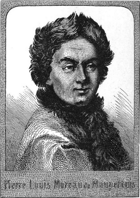 |
| Pierre Louis Moreau de Maupertuis. |
"If," said this scientific man, "the flatness of the earth be not greater then Huyghens supposed, the margin between the degrees of the meridian measured in France, and the first degrees of the meridian near the Equator, would not be too considerable to be attributed to possible errors of the observers, or to the imperfection of instruments. But, if the observation can be made at the Pole, the difference between the first degree of the meridian nearest the equatorial line, and, for example, the sixty-sixth degree, which crosses the polar circle, will be great enough, even by Huyghens' hypothesis, to show itself irresistibly, and beyond the possibility of miscalculation, because the difference would be repeated just as many times as there are intermediate degrees."
The problem thus neatly propounded ought to have obtained a ready solution both at the Pole and the Equator—a solution which would have settled the discussion, by proving Huyghens and Newton to be right.
The expedition embarked in a vessel equipped at Dunkerque. In addition to Maupertuis, it comprised De Clairaut, Camus, and Lemonnier, Academicians, Albey Outhier, canon of Bayeux, a secretary named Sommereux, a draughtsman, Herbelot, and the scientific Swedish astronomer, Celsius.
When the King of Sweden received the members of the mission at Stockholm, he said to them, "I have been in many bloody battles, but I should prefer finding myself in the midst of the most sanguinary, rather than join your expedition."
Certainly, it was not likely to prove a party of pleasure. The learned adventurers were to be tested by difficulties of every kind, by continued privation, by excessive cold. But what comparison can be made between their sufferings, and the agonies, the trials and the dangers which were to be encountered by the Arctic explorers, Ross, Parry, Hall, Payer, and many others.
Damiron in his "Eulogy of Maupertuis," says, "The houses at Tornea, north of the Gulf of Bothnia, almost in the Arctic Circle, are hidden under the snow. When one goes out, the air seems to pierce the lungs, the increasing degrees of frost are proclaimed by the incessant crackling of the wood, of which most of the houses are built. From the solitude which reigns in the streets, one might fancy that the inhabitants of the town were dead. At every step one meets mutilated figures, people who have lost arms or legs from the terrible severity of the temperature. And yet, the travellers did not intend pausing at Tornea."
Now-a-days these portions of the globe are better known, and the region of the Arctic climate thoroughly appreciated, which makes it easier to estimate the difficulties the inquirers encountered.
They commenced their operations in July, 1736. Beyond Tornea they found only uninhabited regions. They were obliged to rely upon their own resources for scaling the mountains, where they placed the signals intended to form the uninterrupted series of triangles.
Divided into two parties in order thus to obtain two measurements instead of one, and thereby also to diminish the chance of mistakes, the adventurous savants, after inconceivable hairbreadth escapes, of which an account can be found in the Memoirs of the Academy of Sciences for 1737, and after incredible efforts, decided that the length of the meridian circle, comprised between the parallels of Tornea and Kittis was 55,023 fathoms and a half. Thus below the Polar circle, the meridian degree comprised a thousand fathoms more than Cassini had imagined, and the terrestrial degree exceeded by 377 fathoms the length which Picard has reckoned it between Paris and Amiens.
The result, therefore, of this discovery (a result long repudiated by the Cassinis, both father and son), was that the earth was considerably flattened at the poles.
Voltaire somewhat maliciously said of it,—
| Courrier de la physique, argonaute nouveau, Qui, franchissant les monts, qui, traversant les eaux, Ramenez des climats soumis aux trois couronnes, Vos perches, vos secteurs et surtout deux Laponnes. Vous avez confirmé dans ces lieux pleins d'ennui Ce que Newton connut sans sortir de lui. |
In much the same vein he alludes to the two sisters who accompanied Maupertuis upon his return, the attractions of one of whom proved irresistible,—
| Cette erreur est trop ordinaire Et c'est la seule que l'on fit En allant au cercle polaire. |
M. A. Maury in his "History of the Academy of Sciences," remarks,—
"At the same time, the importance of the instruments and methods employed by the astronomers sent to the North, afforded a support to the defenders of the theory of the flattening of the globes, which was hardly theirs by right, and in the following century the Swedish astronomer, Svanburg, rectified their involuntary exaggerations, in a fine work published by him in the French language."
Meantime the mission despatched by the Academy to Peru proceeded with analogous operations. It consisted of La Condamine, Bouguer, and Godin, three Academicians, Joseph de Jussieu, Governor of the Medical College, who undertook the botanical branch, Seniergues, a surgeon, Godin des Odonais, a clock-maker, and a draughtsman. They started from La Rochelle, on the 16th of May, 1735.
Upon reaching St. Domingo, they took several astronomical observations, and continued by way of Porto Bello, and Carthagena. Crossing the Isthmus of Panama, they disembarked at Manta in Peru, upon the 9th of March, 1736.
Arrived there, Bouguer and Condamine parted from their companions, studied the rapidity of the pendulum, and finally reached Quito by different routes. Condamine pursued his way along the coast, as far as Rio de las Esmeraldas, and drew the map of the entire country, which he traversed with such infinite toil. Bouguer went southwards towards Guayaquil, passing through marshy forests, and reaching Caracol at the foot of the Cordillera range of the Andes, which he was a week in crossing. This route had been previously taken by Alvarado, when seventy of his followers perished; amongst them, the three Spaniards who had attempted to penetrate to the interior. Bouguer reached Quito on the 10th of June. At that time this city contained between thirty and forty thousand inhabitants, and boasted of an episcopal president of the Assembly, and numbers of religious communities, besides two colleges.
Living there was cheap, with the exception of foreign merchandises, which realized exorbitant prices, so much so indeed, that a glass goblet fetched from eighteen to twenty francs.
The adventurers scaled the Pichincha, a mountain near Quito, the eruptions from which had more than once been fatal to the inhabitants, but they were not slow in discovering that they could not succeed in carrying their implements to the summit of the mountains, and that they must be satisfied with placing the signals upon the hills.
"An extraordinary phenomena may be witnessed almost every day upon the summit of these mountains," said Bouguer in the account he read before the Academy of Sciences, "which is probably as old as the world itself, but what it appeared was never witnessed by any one before us. We first remarked it when we were altogether upon a mountain called Pamba Marca. A cloud in which we had been enveloped, and which dispersed, allowed us a view of the rising sun, which was very brilliant. The cloud passed on, it was scarcely removed thirty paces when each of us distinguished his own shadow reflected above him, and saw only his own, because the cloud presented a broken surface.
"The short distance allowed us fully to recognize each part of the shadow; we distinguished the arms, the legs, the head, but we were most amazed at finding that the latter was surrounded by a glory, or aureole formed of two or three small concentric crowns of a very bright colour, containing the same variety of hues as the rainbow, red being the outer one. The spaces between the circles were equal, the last circle the weakest, and in the far distance, we perceived one large white one, which surrounded the whole. It produced the effect of a transfiguration upon the spectator."
The instruments employed by these scholars were not as accurate as more modern ones, and varied with changes of temperature, in consequence of which, they were forced to proceed most carefully, and with most minute accuracy, lest small errors accumulating should end by leading to greater ones. Thus, in their trigonometrical surveys Bouguer and his associates never calculated the third angle by the observation of the two first, but always observed all three.
Having calculated the number of fathoms contained in the extent of country surveyed, the next point was to discover what part this was of the earth's circumference, which could only be ascertained by means of astronomical observations.
After numerous obstacles, which it is impossible to give in detail, after curious discoveries, as for example the attraction exercised on the pendulum by mountains, the French inquirers arrived at conclusions which fully confirmed the result of the expedition to Lapland. They did not all return to France at the same time.
Jussieu continued his search after facts in natural history, and La Condamine decided to return by way of the Amazon River, making an important voyage, to which we shall have occasion to refer later.